How drones are being used to monitor climate change effects
Anúncios
Drones are increasingly used to monitor climate change effects by efficiently collecting real-time environmental data, enhancing our understanding of ecological changes and helping in conservation efforts.
How drones are being used to monitor climate change effects is becoming increasingly vital in our quest to understand and mitigate environmental issues. More than just high-tech gadgets, drones provide insights that can reshape conservation efforts.
Anúncios
Introduction to drones in climate monitoring
Understanding the role of drones in climate monitoring is crucial today. These high-tech tools help us better analyze and understand environmental changes.
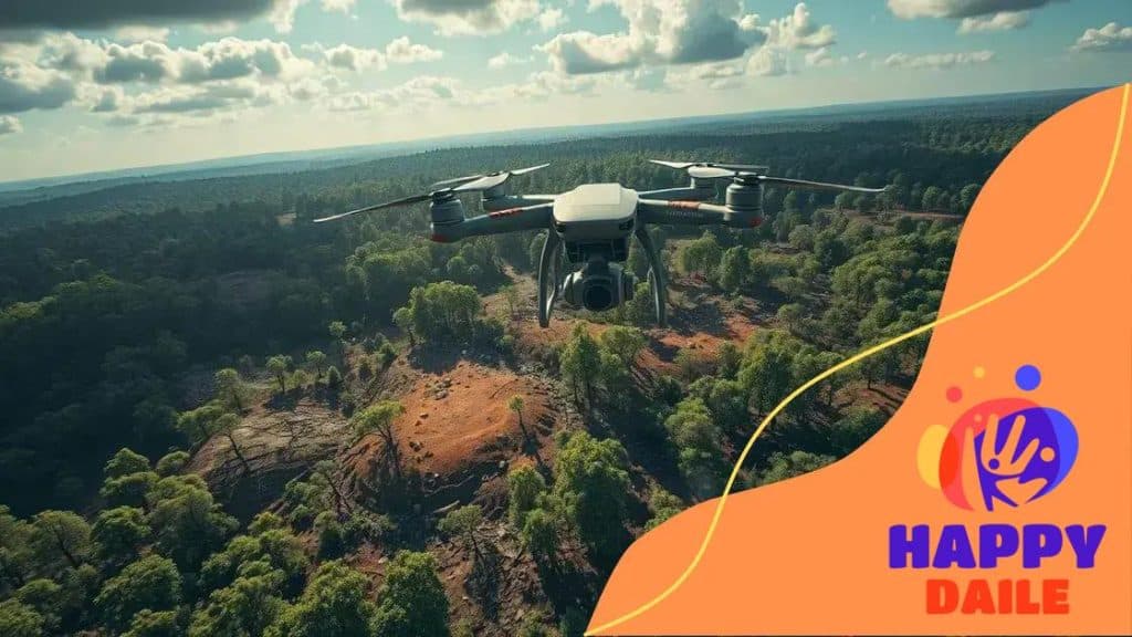
What Drones Do in Climate Monitoring
Drones gather data efficiently, covering areas that are often hard to reach. With various sensors, they collect information on temperature, vegetation, and even air quality.
Benefits of Using Drones
- Cost-effective: Drones are less expensive than traditional surveying methods.
- Real-time data: They provide immediate feedback, allowing for quicker responses to climate-related issues.
- Versatility: Drones can operate in different environments, from urban settings to remote forests.
Moreover, drones assist in monitoring deforestation, ice melt, and more. Their ability to fly at various altitudes means they can capture detailed imagery of affected areas. This data is invaluable for scientists and policymakers, aiming to devise strategies to combat environmental change.
Anúncios
In addition to data collection, drones can also help in disaster response. They track the aftermath of events like wildfires or floods, providing crucial insights into recovery efforts. This feature emphasizes the significant impact that drones have on enhancing our climate response strategies.
As technology evolves, the capabilities of drones will expand, leading to even more precise monitoring methods. The future of drones in climate science is bright, holding potential for innovations that could transform environmental research and conservation practices.
Capabilities of drones for environmental data collection
The capabilities of drones for environmental data collection are transforming the way we monitor our planet. Drones can cover large areas quickly and gather information that is often hard to obtain through traditional methods.
Advanced Sensors
Equipped with advanced sensors, drones can capture a variety of environmental data. These sensors allow them to measure elements like temperature, humidity, and air quality.
Use of Imagery
Drones utilize high-resolution cameras and imaging technology, enabling them to take detailed images of ecosystems. This imagery helps scientists assess the health of forests, water bodies, and wildlife habitats.
- Thermal imaging: This helps in identifying heat patterns, useful for detecting changes in wildlife activity.
- Multispectral images: These images help monitor plant health by measuring different light wavelengths.
- LiDAR technology: Drones with LiDAR can produce precise topographical maps, assisting in soil analysis and land use planning.
Furthermore, drones can operate in areas that are dangerous or inaccessible for humans, like during natural disasters. They provide real-time data, which is crucial for immediate assessment and response. This aspect of drones is vital in understanding the impacts of climate change as they can give insights into environmental changes as they occur.
Continuous advancements in drone technology are making these tools even more effective. As drones become better and more affordable, their role in environmental monitoring is expected to grow, making them indispensable in current and future conservation efforts.
Case studies: Successful drone applications

Exploring case studies of successful drone applications reveals how these devices are changing climate monitoring. Various projects around the world showcase their effectiveness and versatility.
Forest Monitoring in Brazil
In Brazil, drones have been used to monitor deforestation in the Amazon rainforest. They collect high-resolution images that help researchers track changes in vegetation over time. This data is essential for understanding the impacts of both illegal logging and climate change on biodiversity.
Glacier Tracking in Alaska
In Alaska, scientists deployed drones to study glaciers. The drones can gather data on ice thickness and movement, which is crucial for predicting how rising temperatures affect sea level. Their ability to operate in harsh environments makes them an invaluable tool for glaciologists.
- High efficiency: Drones cover large areas quickly and at low cost.
- Safety: They minimize risks to researchers who would work in hazardous conditions.
- Precision: The data gathered is often more accurate than traditional methods.
These case studies demonstrate the potential of drones in various applications. In Australia, drones monitor coral reefs, assessing health and tracking bleaching events caused by climate change. This crucial information helps conservationists develop effective strategies for reef protection.
Moreover, in Africa, drones support wildlife conservation efforts by tracking endangered species from the air. They monitor animal migration patterns and assess habitat changes due to environmental stressors. As we gather more case studies, it becomes clear that the potential of drones is vast, providing insights that were previously difficult to obtain.
Challenges in using drones for climate research
While utilizing drones for climate research offers many benefits, several challenges must be addressed. These challenges can impact the effectiveness of data collection and analysis.
Regulatory Hurdles
One major challenge is navigating the regulations surrounding drone usage. Different countries and regions have specific laws that can restrict where and how drones can be flown. Understanding these regulations can be a barrier, especially for researchers working across borders.
Technical Limitations
Technical issues can also arise. Drones have limitations in battery life, which affects their flight duration. This can restrict the area they can cover in a single flight. Additionally, adverse weather conditions like strong winds or rain can prevent drone operation altogether.
- Battery capacity: Many drones can only fly for 20-30 minutes before needing a recharge.
- Sensor quality: Less expensive drones may have lower-quality sensors, impacting data accuracy.
- Weather dependence: Drones cannot fly safely in severe weather conditions.
Moreover, data management is another significant challenge. The vast amount of data collected by drones requires robust storage and analysis tools. Researchers must ensure they have the right systems in place to process the information efficiently.
Training is crucial as well. Operators need to be skilled in flying drones and interpreting the data collected. Without proper training, the risk of accidents increases, posing safety concerns in research contexts.
Even with these challenges, advancements in technology are helping to mitigate some of the issues. As drone technology evolves, many of these obstacles may become easier to overcome.
Future of drone technology in combating climate change
The future of drone technology in combating climate change appears promising. As technology continues to advance, drones become more efficient and capable of addressing environmental issues effectively.
Innovations on the Horizon
Innovative features are emerging in the drone industry. For instance, enhanced battery life allows drones to stay airborne longer, covering more extensive areas of land. This means that researchers can gather data over larger regions without needing to recharge frequently.
Integration with Artificial Intelligence
The integration of artificial intelligence (AI) is another crucial development. AI can help drones analyze data in real time, providing immediate insights for scientists. This technology leads to quicker decision-making in response to environmental changes.
- Automated data collection: Drones can fly predetermined routes, collecting data autonomously.
- Predictive analytics: AI can help forecast environmental trends based on collected data.
- Enhanced image processing: AI improves the quality of images, allowing for better analysis.
Moreover, future drones may feature advanced sensors that can monitor even more variables, such as soil moisture levels and atmospheric gases. This ability will significantly improve our understanding of ecosystems.
As public and private investment in drone technology increases, more research and application opportunities will arise. Collaboration between governments, universities, and tech companies will accelerate the development of solutions aimed at tackling climate change.
Additionally, regulatory frameworks will likely adapt to accommodate the growing use of drones. As policies evolve, they may become more supportive of innovative drone applications in environmental science.
FAQ – Frequently Asked Questions about Drones and Climate Change Monitoring
What role do drones play in climate change monitoring?
Drones collect environmental data quickly and efficiently, monitoring changes in climate and ecosystems.
What are the benefits of using drones for data collection?
Drones can cover large areas, gather real-time data, and operate in hard-to-reach locations, making data collection more effective.
What challenges do drones face in climate research?
Drones face regulatory hurdles, technical limitations, and the need for skilled operators to use them effectively.
How is drone technology expected to evolve in the future?
Future developments may include better battery life, advanced sensors, and integration with AI for real-time data analysis.


